• Home
  • Quick Guide
    • Quick Guide
    • New User of MapRun
    • Capability Statement
  • MapRun App
    • MapRun6
    • MapRun - QuickStart
    • MapRun - CheckSites
    • MapRun - Any Track
    • MapRun - Events
    • MapRun - Event Options
    • How to Participate
    • MapRun - Review Results
    • MapRun - Options and Settings
    • MapRun - Bluetooth GPS
  • MapRunG
  • Forum
  • Technical
    • Versions of MapRun >
      • MapRun v7
      • Releases MapRun version 7
      • Releases MapRun6
      • MapRun Servers
    • How-To Guides >
      • Step by Step Guide
      • Accurate Control Lat/Lng
      • Publishing an Event to MapRun
      • Slides and Videos
    • Maps and Courses >
      • Maps - KMZ Files
      • Course Setting
      • Course Setting Guidelines for GPS
      • OCAD Maps and Courses
      • Event Types
      • Scoring Schemes
    • Features and Options >
      • Punching Controls
      • Tag-based Punching
      • Confirmed Finish
      • Pause Timing for a Leg
      • Parameter-based Scoring - ScoreP
      • Live Tracking
    • Troubleshooting >
      • Phone Settings
      • Issues with GPS
      • Strava - Problem Solving
      • Reporting Issues
    • Administration Functions >
      • MapRun Console
      • Access to Results
      • MapRunLink
      • Event Information
      • Deletion and Archival
      • Publicising an Event
      • Introduction for New Users
      • GPS Watch Track Upload
      • Checking Results
  • About
    • Contact
    • User Agreement
    • MapRun Logo
MapRun®
Connect with Us:

MapRun - CheckSites

CheckSites
  • This option lets you publish a confidential event to the server. This is typically used:
    • To test new map and course files to confirm that they are compatible with MapRun, or
    • To publish an event for testing in the field, or
    • To check the placement of "conventional" controls in the field (to ensure they are on the correct feature),
    • To note features on the map that need to be updated
    • or
    • To set up a simple event for your own private use.
  • This feature of MapRun allows you to publish a confidential copy of your map, then use the 6-digit code provided, to access the map.
  • If you use the event for testing in the field - you will be able to see your present position on the map as you check control sites.
  • CheckSites uses:
    • A map file (in KMZ format) ... but you can skip needing a map if you don't have one
    • A course file (in KML format) ... this is just a set of location pins exported from Google Earth/Google Maps or similar.... but if you just want to see your location on your map, upload a map file, but you don't need a course file as well.
  • In summary, to use this feature, you need to upload at least a Map or a Course file (and optionally both). ​
  • See this document for more information on using CheckSites to check the control sites for a conventional Orienteering event and to note any map updates.
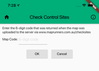
  • Upload your file(s) at the MapRunners CheckSites page and take note of the 6-digit code you will be given
  • In MapRun6, tap the menu button on the home screen and  select "Check Sites"
  • Enter the 6-digit code, and your map/course will be available on your phone.
  • See the MapRun Events page for more details on managing Events in the App.​
Picture
Copyright  (c) 2018-2021 MapRun® is a registered trademark